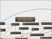
Concept map of the lines of research related to the snow avalanches and land use planning

r

Aquest mapa conceptual es proposa per discussió i millora pels mateixos investigadors.L'existència de relacions entre línies d'investigació conforma la importància dintre del corpus d'investigació. Així a mesura que una línia d'investigació s'apropa al cor del corpus obté un número més proper a 1. En la pràctica les línies d'investigació més antigues tenen més proximitat al cor, mentre que les línies més noves, - s'han originat com una branca d'una línia més antiga -, o menys estudiades, es situen cap a l'extrem.Les línies d'investigació tecnològiques i estadístiques impregnen totes les altres de forma complementària.

Forecasting

Thermal conductivity

Stratigraphy

Meteorology

Wet snow

Geomorphology

Risk maps of snow avalanches

Pressure - interaction with structures

Representation of the snow on the Earth's surface

Risk assessment

Dynamics of avalanches

Strategy and search for victims

Rheology

Forests

Seismicity, acoustic waves, infrasound sensor networks

Source: own

Stability of the snow cover

Front speed - Distance traveled

Technology

Explosives

Monitoring of snow avalanches

Regional/spatial planning

Statistics

Metamorphism of the snow cover

Transport of snow


Climate