Șabloane > Geografie >

World Countries Template

World Countries Template

Collect and organize information about the geographical features of a country/state/county.

Keywords: Geography, country features, learning countries, geographical features

World Countries Template

Learn countries of the world

Learn countries of the world by completing this template with characteristics about each country. For example, think about geographical features like the length of the rivers, the height of the mountains, what are the neighbors, etc.

Also, after you choose the country you are going to analyze, respond to questions like the ones below:

On which continent is this country located?

What are the Main Physiographic Divisions of this country?

What are the languages spoken in this country?

What is the climate of this country?

What are the major cities of this country?

What is the population of this country?

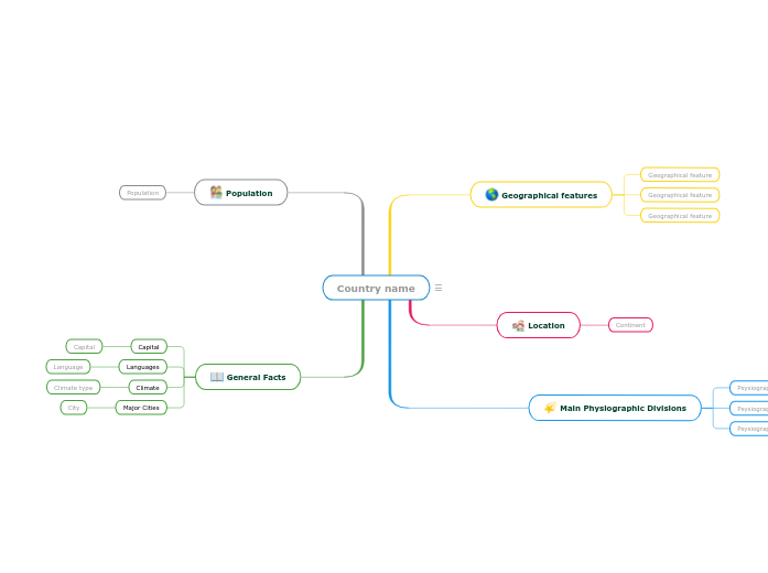
Country name

Keywords: countries, states, geography, cities, capital city, climate, physiographic divisions


Write the name of the country/state/county you are going to analyze. Then add a representative image.

General Facts

Think about this general facts about Country name.

Major Cities
City

A major city from Country name

Climate
Climate type

A climate type from Country name

Languages
Language

A language spoken in Country name

Capital

The capital of Country name

Population

What is the population of Country name?

The number of people living in Country name

Main Physiographic Divisions

Physiographic regions of the world are a way of defining Earth's landforms into distinct regions.

What are the Physiographic regions of Country name?

Psysiographic Division

Location

What is the continent where Country name is located?

Continent

Geographical features

Add geographical features of Country name. They can be related to the length of the rivers, the height of the mountains, what are the neighbours etc.
Geographical feature

Add a geographical feature. It can be related to the length of the rivers, the height of the mountains, what are the neighbours etc.
De ce să folosiți un șablon de hartă mentală Mindomo?

Hărțile mentale vă ajută să faceți brainstorming, să stabiliți relații între concepte, să organizați și să generați idei.

Cu toate acestea, șabloanele de hărți mentale oferă o modalitate mai ușoară de a începe, deoarece acestea sunt modele care conțin informații despre un anumit subiect cu instrucțiuni de ghidare. În esență, șabloanele de hărți mentale asigură structura care combină toate elementele unui anumit subiect și servesc drept punct de plecare pentru harta mentală personală. Ele sunt o resursă care oferă o soluție practică pentru a crea o hartă mentală pe un anumit subiect, fie pentru afaceri sau educație.

Mindomo vă oferă șabloane inteligente de hărți mentale care vă permit să acționați și să gândiți fără efort.

Un șablon are diverse funcționalități:

Subiecte descriptive

Subiecte cu text de fundal

Ramură implicită

Eliminarea datelor șablonului

Puteți alege dintr-o varietate de șabloane de hărți mentale din conturile pentru afaceri sau educaționale ale Mindomo sau puteți crea propriile șabloane de hărți mentale de la zero. Orice hartă mentală poate fi transformată într-o hartă șablon prin adăugarea de instrucțiuni de ghidare suplimentare la unul dintre subiectele sale.