类别 全部 - data - perspectives - patterns - gps

作者:jacob jennings 3 年以前

98

Thinking like a Geographer-Jacob

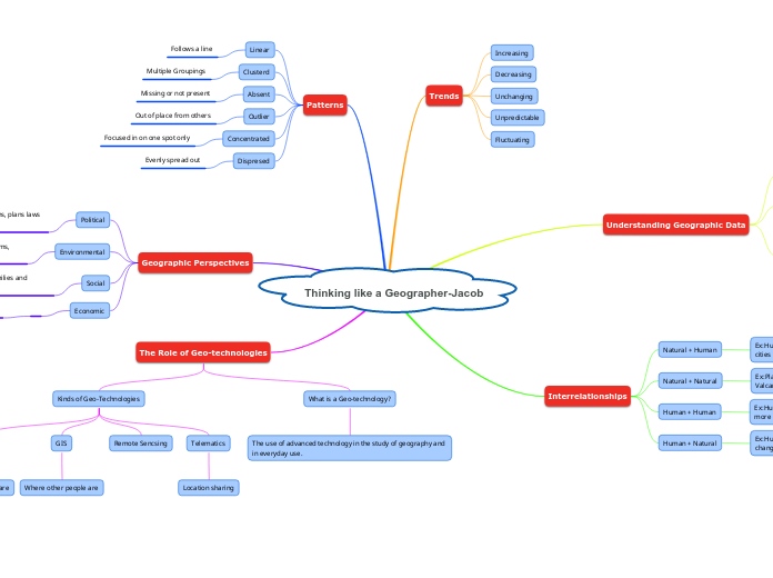
The integration of advanced technology in geography, known as geo-technologies, plays a pivotal role in both academic study and practical everyday applications. These technologies include tools like GPS, telematics, remote sensing, and GIS, each serving different purposes such as location sharing and identifying where people are.

Thinking like a Geographer-Jacob

Thinking like a Geographer-Jacob

The Role of Geo-technologies

What is a Geo-technology?
The use of advanced technology in the study of geography and in everyday use.
Kinds of Geo-Technologies
Telematics

Location sharing

Remote Sencsing
GIS

Where other people are

GPS

Where you are

Geographic Perspectives

Economic
Social
The connection or impact on people’s lives, families and everyday living.
Environmental
The connection or impact on the environment, ecosystems, organisms
Political
The connection or impact of government decisions, plans laws and choices

Patterns

Dispresed
Evenly spread out
Concentrated
Focused in on one spot only
Outlier
Out of place from others
Absent
Missing or not present
Clusterd
Multiple Groupings
Linear
Follows a line

Interrelationships

Human + Natural
Ex:Humans polution all over the earth in causing climate change
Human + Human
Ex:Human polulation to Cities and houses.. Where ever there is more people there would be more cities and houses.
Natural + Natural
Ex:Plates moving in the Earth causes Earthquakes and Valcanoes
Natural + Human
Ex:Humans cut down forests to make houses,towns and even cities

Understanding Geographic Data

Geographic data can be visualized in 3 different ways.
Graphs
Charts
Maps
Attribute Data is Data that meets or doesnt meet a sartification
Understanding Geographic data is information that has explicit or implicit association with a location relative to Earth.

Trends

Fluctuating
Unpredictable
Unchanging
Decreasing
Increasing