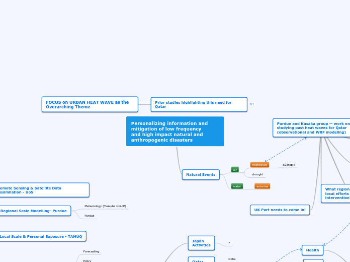
Purdue and Kusaka group -- work on studying past heat waves for Qatar (observational and WRF modeling)
UK Part needs to come in!
Future climate?
Yang, Long, Dev Niyogi, Mukul Tewari, Daniel Aliaga, Fei Chen, Fuqiang Tian, and Guangheng Ni. "Contrasting impacts of urban forms on the future thermal environment: example of Beijing metropolitan area." Environmental Research Letters11, no. 3 (2016): 034018.
What regions are vulnerable and how can local efforts help reduce need for medical intervention?
how can greening infrastructure improve heat stress reduction?
How can remote sensing help improve urban heat wave mapping and prediction
Past studies cases
FOCUS on URBAN HEAT WAVE as the Overarching Theme
Prior studies highlighting this need for Qatar
https://www.gulf-times.com/story/614831/Study-Climate-change-increases-heat-related-diseas
https://www.qscience.com/docserver/fulltext/connect/2014/1/connect.2014.9.pdf?expires=1559337246&id=id&accname=guest&checksum=5F779B27C69A710C8E9A15820C788C7F
Overarching THEME
Stakeholder Inspired DR3 Framework
End goal could be a synthesis and demonstration of how to integrate regionally useful and usable DR3 tools.
- Each country could develop specific examples/tools
- Share what we have with each other in Year 2 and improve on what we have for that region (e.g. urban model from Tokyo for urban flooding over US; or findings about user needs from UK in testing the model performance beyond the traditional metric of rainfall output)
- in Year 2 leaning to year 3 we develop synthesis for implementation and tests with Qatar (so end goal will be demonstration and implementation in Qatar but elements of developments will be achieved in each country specifically building on the specific strengths). This would mean we need to have a common goal e.g. Urban Heat Stress
Case Studies
US
Activities
East Coast
UK
Activities
SouthEast Catchment
Qatar
Activities
MoPH/PHCC
Doha
Japan
Activities
?
Stake Holders
Environment
Economic
Social
Health
Deliverables
Mobile App
Mitigation Strategies
Forecasting Tools
Assessment Risk
(Mapping Vulnerability)
population
infrustructure
WorkPackages
& SubModels
Mitigation Strategies - Tsukuba
crops & etc
Personal
Economic Analysis
Policy
Forecasting
Local Scale & Personal Exposure - TAMUQ
Regional Scale Modelling- Purdue
Purdue
Meteorology (Tsukuba Uni-JP)
Remote Sensing & Satellite Data Assimilation - UoS
Personalizing information and mitigation of low frequency
and high impact natural and anthropogenic disasters
Natural Events
water
extreme
air
drought
heatwaves
Subtopic


