MANUAL DE PROCEDIMIENTO DE CONCILIACION CARTOGRAFICA
The part of speech is a category to which a word is assigned according to its syntactic functions. In English the main parts of speech are noun, pronoun, adjective, determiner, verb, adverb, preposition, conjunction, and interjection.
IV. TAREAS DEL OPERADOS CARTOGRAFICO
An adverb is used to describe a verb, but it can also describe an adjective or another adverb.
Adverbs normally help paint a fuller picture by describing how something happens.
4.2 DURANTE
descarga de información
PROCEDIMIENTO 02: COPROBACION DE LA GEOREFERENCIACION
CASO1: COMPROBACION DE GEORREFERENCIACION
en la imagen nos indica los puntos ingresados
para visualizar los puntos digite DDPTYPE
insertar coordenadas de los vertices
digite point en barra de comandos
se utilizara coordenadas obtenidas en la toma de púntos de control.
TOMA DE 02 PUNTOS
llevara hacia el centro poblado
parte superior izquierda BUSCAR
opciones del google earth
configuración del sistema
captura de púntos portal
toma de puntos GPS
PAUTAS DE PROCESAMIENTO DE INFOMRACION DESCARGADA
INTEGRACION DE SHAPEFILE
integración de la información trabajada
SISTEMATIZACION
trabajo con los shapefile
METODO 4
digitalización de las capaz
captura de imagen satelital
METODO 3
sistematización
digitalización de capaz temáticas
escaneo, definición del sistema de proyección
aplicativos de carpeta
se debe seleccionar ámbito geográfico urbano o rural.
seleccione tipo de estructura de carpetas
click izquierdo en el botón estructuras de carpeta
click izquierdo en el botón descargas
estructuras de carpeta, click izquierdo botón ingresar
ingresas el disco DVD y dar doble click izquierdo
4.1 ANTES
Organizacion y capacitacion de equipo de trabajo
Es importante la capacitacion durante el taller de gesion integral del marco territorial.
El operados es responsable de la conciliacion y debera realizar el efecto cascada con la persona de la muni para el apoyo de la labor.
Eleccion de metodos de conciliacion cartografica
CASO 2:
Si la munic cuenta con informacion de autocad digital vectorial el resto con informacion analogica
Usar la georreferenciacion mediante 2 puntos de control y conversion a shapefile y sistematizacion de areas parciales.
CASO 1:
Si la muni cuenta con informacion cartografica en autocad area parcial y el resto con cartofrafica digital .
Usar comprobracion de georreferenciacion mediantes 2 puntos de control y conversion del shapefile y sistematizacion de areas parciales
Analisis y equivalencia de informacion cartografica INEI
Antes de iniciar se realiza un analisis fisico
Equivalencia ambito rural
Equivalencia en ambito urbano
Implementacion y acondicionamiento
Contar con espacio propio de acuerdo a las necesidades que cuente la Municipalidad.
Descripcion Autocad
Caracteristicas QSIS
Caracteristicas ARCGIS
Google eart Pro
Verificacion de recursos humanos
El operador debe realizar la lista de materiales y equipos
Recopilacion y verificacion
Revisar y verificar el tipo, estructura y referencia espacial
Etapa 3: Despues
Consiste en identificar y subsanar posibles errores generados en la conciliacion.
Etapa 2: Durantes
Describe proceso de ejecucion del aplicativo de carpetas del shapefile.
Etapa 1: Antes
Comprende la recopilación y verificación de información cartográfica.
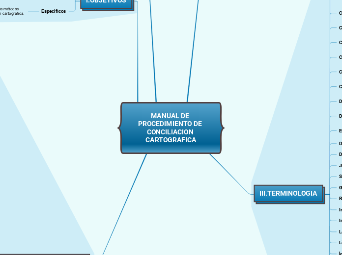
I.OBJETIVOS
A numeral is a word or phrase that describes a numerical quantity.
Some theories of grammar use the word 'numeral' to refer to cardinal numbers that act as a determiner to specify the quantity of a noun, for example the 'two' in 'two hats'.
Especificos
Asegurar, precisar y proporcionar los métodos estandarizados para la conciliación cartográfica.
General
Brinda información detallada y secuencial de las etapas y sus procedimientos necesarios par ala conciliación.
INTEGRANTES:
CANO LLANCO RANDY
GAMBOA CURO JAYO
III.TERMINOLOGIA
A noun is defined as a person, place, thing or idea. Proper nouns always begin with a capital letter. Common nouns, which are general words, such as 'cars,' are not capitalized.
ZONA UTM
zona censal
WGS84
UTM
topografia
tabla de atributo
sistematizacion
sistema de informacion geografica
sistema de proyeccion
sistema de coordenada
PSAD56
punto de referencia
punto
poligono
plano
nucleo urbano
manzana
mapa distrital
longitud
Linea o polilinea
Latitud
Informacion catografica digital
Imagenes satelitales
RASTER
Georreferenciacion
SHAPEFILE
JPG
DXF
DWG
Escala
Relacion de distancia entre 2 puntos.
Digitalizacion
Convertir formato analógica en digital
Datum
Modelo en forma de tierra
Coordenadas geograficas
Utiliza 2 coordenadas angulares N-S
Consistencia cartografica
validacion de informacion cartografica
Comprobacion de georreferenciacion
Verificacion del sistema de coordenadas
Centro poblado urbano
100 viviendas agrupadas continuas
Centro poblado rural
Lugar que cuenta con mas 100 viviendas
Cartografia
Ciencia y arte de la superficie terrestre
Capa tematica
Componentes y elementos geograficos
Base de datos
Compound nouns are words where two nouns have been stuck together to make a new noun. Compound nouns should be written as one word, without a hyphen.
Conjunto de datos organizados
Ambito urbano
A noun which refers to a group of things/people.
Parte del territorio de un distrito,conformada por centros poblados.
Ambito moral
Countable nouns are nouns that can be counted, even if the number might be extraordinarily high.
Uncountable nouns are nouns that come in a state or quantity which is impossible to count; liquids are uncountable, as are things which act
like liquids.
Parte del territorio de un distrito
Actualizacion Cartografica
Proper nouns are the names of specific people or places. They should always begin with a capital letter.
Conjunto de tareas a captar informacion.
II.ORGANIZACION PARA LA CONCILIACION CARTOGRAFICA
A verb is an action word or 'doing' word that signifies movement in some way.
Funciones del Operador cartografico
A linking verb connects the subject with a word that gives information about the subject, such as a condition or relationship.
Persona designada por la Municipalidad, es encargada de conducir y realizar la conciliacion.
Asegurar que la información ingrese al SIGIT.
Asistir puntualmente a sesiones de taller.
Registrar informacion en el documento
Organización Funcional
A verb with its own meaning: a verb that is not an auxiliary verb.
Referida a la conduccion, jefatura del proyecto y ejecución operativa.
Monitoreo tecnico.
Direccion ejecutiva de cartografica y geografia.
