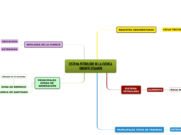
SISTEMA PETROLERO DE LA CUENCA ORIENTE ECUADOR
The first division between continents was made by ancient Greek navigators, who named them 'landmass, terra firma'.
Generally classified by convention rather than any strict criteria, nowadays seven regions are regarded as continents from a geopolitical point of view.
PRINCIPALES ZONAS DE GENERACIÓN
Antarctica is not only the coldest place on Earth but also the highest, driest, windiest and emptiest, completely covered with ice.
75% of the world's ice and 70% of the Earth's fresh water is located here.
Summer months of December to February give 24 hours of light, while the winter months of late March to late September are pitch dark the whole day.
There are no permanent inhabitants, except for scientists maintaining research stations in Antarctica.
CUENCA DE SANTIAGO
Antarctica sees half a year of light and half a year of complete darkness.
Write down which months give 24 hours of light, and which are the ones that give pitch darkness the whole day.
Ubicada en el suroeste
ZONA DE BERMEJO
The coldest natural temperature ever recorded on Earth was recorded here.
Write it down.
Ubicada en el noroeste
GEOLOGIA DE LA CUENCA
North America has five time zones and it is the only continent with every type of climate.
North America was named after the explorer Amerigo Vespucci and is also known as the 'New World'.
The world's largest sugar exporter among the seven continents - Cuba - also called the 'sugar bowl of the world' is located here.
EXTENSIÓN
The world's largest freshwater lake by surface area and the third-largest freshwater lake by volume can be found here. It provides a route for the transportation of iron ore, as well as grain and other mined and manufactured materials.
Large cargo vessels called lake freighters, as well as smaller ocean-going freighters, transport these commodities across this lake.
Name this lake.
aproximada de 100,000 km2
UBICACION
There are 23 countries that make up North America.
Name as many of you can! Don't forget about their capitals.
Situada entre la faja plegada al oeste y el cratón de Brasilia-Guayana
PRINCIPALES TIPOS DE TRAMPAS
Australia is the world's smallest continent and is also known as an 'island continent' as it is surrounded by water on all sides.
It includes 14 countries and it is the least populated continent.
Its name comes from the Latin word 'australis' meaning 'southern' because it lies entirely on the south of the equator.
ESTRUCTURA ANTICLINALES
Trampas combinadas de la Cuenca Oriente. Campo Bermejo Sur, Yacimiento El Rayo.
Trampas estructurales de la Cuenca Oriente. Tiputini – ITT
Trampas estructurales de la Cuenca Oriente. Shushufindi
Trampas estructurales de la Cuenca Oriente. Pungarayacu
SISTEMA PETROLERO
Asia is the world's largest continent of the seven continents in size, as it covers one-third of the earth's surface.
It includes 50 countries, and it is the most populated continent, 60% of the total population of the Earth lives here.
ELEMENTO
Name as many as you can out of the 48 countries located in Asia.
Write down the capitals too.
ROCA MADRE
Potenciales
Serie de sondeos exploratorios profundos.
Probadas
Conformadas por pelitas de origen marino.
REGISTRO SEDIMENTARIO
Europe is separated from Asia by the Ural mountains and the Caspian Sea.
It is surrounded by water on three sides: Mediterranean Sea in the south, Atlantic Ocean in the west, and the Arctic Ocean in the north.
Three-fourth of the world's potatoes grow in Europe.
CICLO TECTONO-SEDIMENTARIO
The most beautiful cities in the world can be found in Europe. History, architecture, arts, and famous cuisine is representative almost to each country.
Out of 51 countries how many you can name?
And how many capitals?
TERCER CICLO
Componen los depósitos del Paleógeno y Neógeno.
FORMACIÓN
NEÓGENO
Arajuno
Chambira
Mera
PALEÓGENO
Tena
Tiyuyacu
Orteguaza
Chalcana
SEGUNDO CICLO
Unidades del Cretácico al Terciario Inferior.
Subtopic
Formación Hollín
Grupo Napo
Formación Tena
PRIMER CICLO
Unidades Pre-Cretácico o Ciclo Pre-Aptiano.
FORMACIONES
Pumbuiza
Macuma
Santiago/Sacha
Chapiza-Yaupi-Misahualli/Tambococha
