Maler > Geografi >

World Countries Template

World Countries Template

Collect and organize information about the geographical features of a country/state/county.

Keywords: Geography, country features, learning countries, geographical features

World Countries Template

Learn countries of the world

Learn countries of the world by completing this template with characteristics about each country. For example, think about geographical features like the length of the rivers, the height of the mountains, what are the neighbors, etc.

Also, after you choose the country you are going to analyze, respond to questions like the ones below:

On which continent is this country located?

What are the Main Physiographic Divisions of this country?

What are the languages spoken in this country?

What is the climate of this country?

What are the major cities of this country?

What is the population of this country?

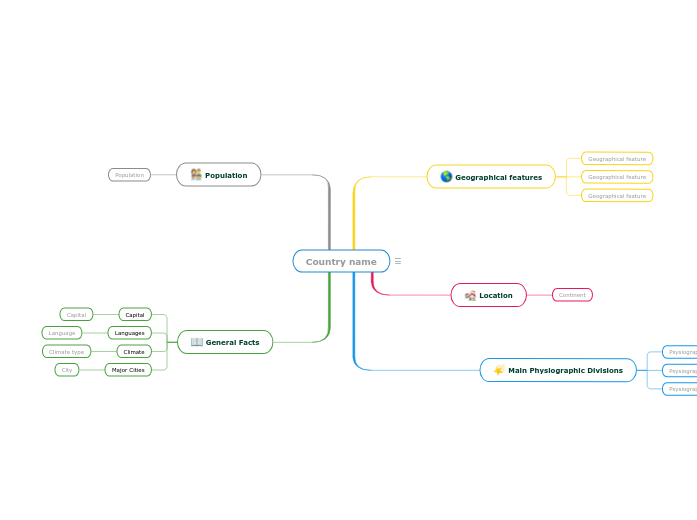
Country name

Keywords: countries, states, geography, cities, capital city, climate, physiographic divisions


Write the name of the country/state/county you are going to analyze. Then add a representative image.

General Facts

Think about this general facts about Country name.

Major Cities
City

A major city from Country name

Climate
Climate type

A climate type from Country name

Languages
Language

A language spoken in Country name

Capital

The capital of Country name

Population

What is the population of Country name?

The number of people living in Country name

Main Physiographic Divisions

Physiographic regions of the world are a way of defining Earth's landforms into distinct regions.

What are the Physiographic regions of Country name?

Psysiographic Division

Location

What is the continent where Country name is located?

Continent

Geographical features

Add geographical features of Country name. They can be related to the length of the rivers, the height of the mountains, what are the neighbours etc.
Geographical feature

Add a geographical feature. It can be related to the length of the rivers, the height of the mountains, what are the neighbours etc.
Hvorfor bruke en Mindomo-tankekartmal?

Tankekart hjelper deg med å brainstorme, etablere relasjoner mellom begreper, organisere og generere ideer.

Tankekartmaler er imidlertid en enklere måte å komme i gang på, ettersom de er rammeverk som inneholder informasjon om et bestemt emne med veiledende instruksjoner. Tankekartmaler sørger for en struktur som kombinerer alle elementene i et bestemt emne og fungerer som et utgangspunkt for ditt personlige tankekart. De er en ressurs som gir deg en praktisk løsning for å lage et tankekart om et bestemt emne, enten det er i forbindelse med jobb eller utdanning.

Mindomo gir deg smarte maler for tankekart som gjør at du kan fungere og tenke uanstrengt.

En mal har ulike funksjoner:

Beskrivende emner

Emner med bakgrunnstekst

Standardgren

Fjerne maldataene

Du kan velge mellom en rekke maler for tankekart fra Mindomos bedrifts- eller utdanningskontoer, eller du kan lage dine egne tankekartmaler fra bunnen av. Et hvilket som helst tankekart kan gjøres om til en mind map-mal ved å legge til flere veiledende notater til et av temaene.