Luokat: Kaikki - riesgo - planificación - estabilidad - meteorología

jonka Luis Cobo 11 vuotta sitten

460

Conceptual map of the research lines related to the snow avalanches and land use planning.

Las líneas de investigación relacionadas con las avalanchas de nieve y la planificación del uso del suelo se interconectan y forman un corpus complejo que se organiza según su antigüedad y centralidad.
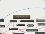
Conceptual map of the research lines related to the snow avalanches and land use planning.

Climate

Transport of snow

Metamorphism of the snow cover

Statistics

Regional/spatial planning

Monitoring of snow avalanches

Explosives

Technology

Front speed - Distance traveled

Stability of the snow cover

Source: own

Seismicity, acoustic waves, infrasound sensor networks

Forests

Rheology

Strategy and search for victims

Dynamics of avalanches

Risk assessment

http://www.mindomo.com/edit.htm?m=c475be68b22f4f5dbeeacfa5191ddb91

Representation of the snow on the Earth's surface

Pressure - interaction with structures

Risk maps of snow avalanches

Geomorphology

Wet snow

Meteorology

Stratigraphy

Thermal conductivity

Forecasting

Concept map of the lines of research related to the snow avalanches and land use planning

Aquest mapa conceptual es proposa per discussió i millora pels mateixos investigadors.

L'existència de relacions entre línies d'investigació conforma la importància dintre del corpus d'investigació. Així a mesura que una línia d'investigació s'apropa al cor del corpus obté un número més proper a 1. En la pràctica les línies d'investigació més antigues tenen més proximitat al cor, mentre que les línies més noves, - s'han originat com una branca d'una línia més antiga -, o menys estudiades, es situen cap a l'extrem.

Les línies d'investigació tecnològiques i estadístiques impregnen totes les altres de forma complementària.