Categorias: Todos - mapping - environment - ethical - communication

por Sodhi Jasmine 7 anos atrás

175

GPS Consequence Map

GPS technology serves a broad array of functions across various sectors. In transportation, it is integral for air and maritime navigation as well as rail systems, enhancing safety and efficiency.
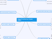
GPS Consequence Map

Global Positioning System (GPS)

Global Consequences

They are widely used by countries around the world to do many things
GPS are useful for mapping, locating, and analyzing geographical details, human infrastructure, and forecast all around the world

Personal Consequences

Can help you keep track of your pets
Can help you find your lost device
Parents can keep track of children, or locate them if they're lost
Can help you find your way around different places in world with mapping support

Environmental Consequences

Modernization of GPS will further enhance support of GPS technology to the study and management of the environment
They help to anticipate upcoming earthquakes
They also help with weather forecasts, by determining the water content of the atmosphere
By tagging imagery with GPS coordinates it is possible to evaluate conservation efforts and assist in strategy planning
GPS technology used to evaluate an area's wildlife, terrain, and human infrastructure

Social Consequences

Easier to track you when you call for help (911)
Can help keep track of criminals
Helps people find locations
Made the environment a more safer place to live
Has changed the way we communicate and live
Huge impact on society

Local consequences

Multi path results in errors in measurements, affecting the positioning accuracy, since the signal takes a longer path than the direct signal
GPS multi path caused by reception of signals arrived not only directly from satellites, but reflected or diffracted from local objects.
GPS multi path can be caused interference between two radio waves which have traveled different length paths between the transmitter and the receiver

Economical Conequences

Maritime transportation- Private sector use of nautical charts and related marine information
Rail transportation- Positive train control
Air transportation
Surveying different topics
Construction- Earth moving with machine guidance
Precision Agriculture- Grain

Legal and Ethical Consequences

Parents can track their child's location, but it is not ethically correct to be tracking someone's location regularly
Employers can track employees, but it is not ethically correct to do so

Scientific Consequences

Useful for marine analyzation
Can be used to anticipate upcoming natural disasters
Can be used to analyze atmospheric conditions
Uses reflection and Diffraction
Uses Radio and Electromagnetic waves